Skip to content
«KAZGISA» – Геоинформационные технологии и дистанционное зондирование Земли

«KAZGISA» - Геоинформационные технологии и дистанционное зондирование Земли

  • Home
  • Services
    • ⠀
      • Development of IT products
        • Business process automation
        • Development of geoinformation systems
        • Technical support
        • Web design development
        • Creating videos
      • Development of IT concepts
        • Digital Master Plan
        • Digital PDP
        • Digital Twin
      • GIS
        • RGIS
        • Development of geoinformation systems
        • Map services (geoportals)
        • Thematic and topographic mapping
      • Project activities
        • Development of a detailed planning plan (PDP)
        • Development of the master plan
    • ⠀
      • Remote sensing of Earth
        • Aerial photography
        • 3D aerial photography
        • Monitoring of common minerals
        • Monitoring of land use
      • Geodesy
        • Inventory of engineering networks
        • Information security
        • Survey of geodetic points
        • Topographic survey
      • BIM modeling
        • Creating three-dimensional models
        • 3D general plan of the enterprise
        • PLM Systems (Product Lifecycle Management Systems)
      • Information security
  • About
  • Contacts
  • English
    • Қазақ тілі
    • Русский

Category: Project activities

Development of the master plan

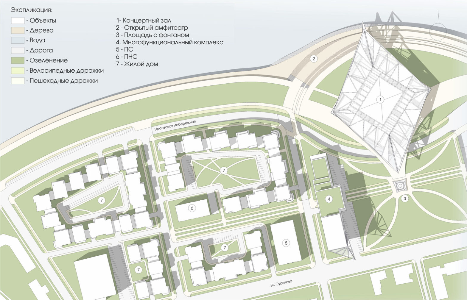
The master plan is a document that is being prepared for plots intended for development. The general plan of the site is necessary for the development of the project and evaluation of its technical and economic indicators. This is the basic scheme, which contains data on the structure of the site, its zoning, transport provision… Continue reading Development of the master plan

Published 12.08.2022
Categorized as Project activities

Development of a detailed planning plan (PDP)

If there is a land plot, what can be placed on it, what to build, what requirements does the administration impose? These and many other points are determined by the PDP – a detailed layout plan. The document reflects the scheme of the district in the city system, urban planning zoning, places for housing, educational… Continue reading Development of a detailed planning plan (PDP)

Published 12.08.2022
Categorized as Project activities

    Остались вопросы? Оставьте ваши данные и мы с вами свяжемся


    Navigation

    • Home
    • About
    • Contacts

    Services

    • Business process automation
    • Aerial photography
    • Map services (geoportals)
    • Development of geoinformation systems
    • Topographic survey

    Contacts

    • info@kazgisa.kz
    • +7 (7172) 73 49 85
    • Nur-Sultan, Alikhan Bokeikhan 28, np-7
    «KAZGISA» – Геоинформационные технологии и дистанционное зондирование Земли